Dear HuntingReader,
KU Leuven, VITO, INBO and Informatie Vlaanderen are part of the GEO. INFORMED project in search of locations with wild boar damage. Through the call below, they hope to receive information from the hunting sector as well, so that the model they are working on can be optimally developed.
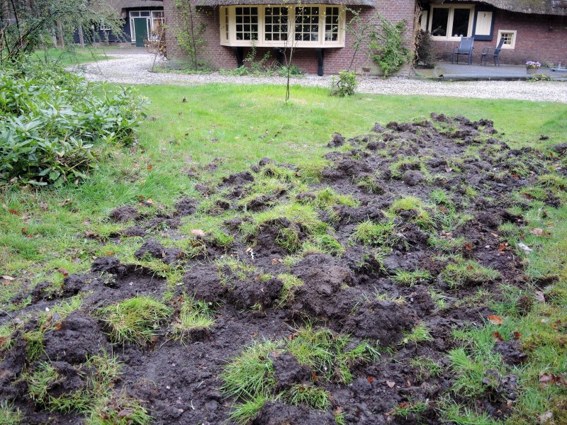
The populations of wild boars in Flanders have increased in recent years, especially in Limburg, parts of Antwerp and Flemish Brabant. This has also increased the number of cases of damage to crops (especially maize) and grasslands. Currently, the extent of damage caused by wild boars in Flanders is not mapped. In her doctoral research from 2019, Anneleen Rutten demonstrated that we can map damage caused by wild boars in a plot in detail with drones. However, this drone method does not allow for efficient damage mapping on a large scale. That is why we are looking for other ways to scale up damage detection in Flanders. In the GEO. INFORMED project, we want to use satellite images to detect damage in agricultural plots. However, to develop our detection models, we need a lot of reference data. We can use the drone images from Anneleen’s research for this, but we want to expand it to more recent damage and in other areas. For that, we need your help.
If you detect damage in one of your maize plots and/or grasslands between 1 September and 15 March, please contact Lennert Destadsbader (researcher KU Leuven – tel. 0478 818 275). He will make an appointment with you for a drone flight over the damaged plot. The data we collect in this way will not directly give rise to compensation. We will use them to develop an operational detection model with which we hope to be able to make a better estimate of the extent of damage caused by wild boars to agricultural plots in Flanders in the long term.
Jim Casaer (INBO), Anneleen Rutten (INBO), Lennert Destadsbader (KUL), Stien Heremans (KUL-INBO), Ben Somers (KUL)
As hunters, we have both feet in the field. As a result, we know very quickly when damage occurs. From HVV, we therefore call on our WBEs and their members to participate in this project. The more images one can collect, the more accurately the model can ultimately estimate the damage from satellite images.
May we ask you to share this call with your members.
With kind regards,
Gert Michiels
Scientific staff member Knowledge Centre